 Norsk
Norsk
Nordaustlandet's history and cultural remainsBy Kristin Prestvold
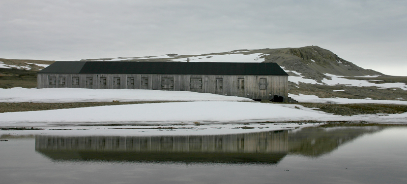

The coastline between the western and northern part of Nordaustlandet was known in the 1600s because the old whalers carried out mapping as well as whaling. They needed to describe the waters around Spitsbergen. Knowledge of coastlines, safe ports and hunting grounds were important. Reconnaissance ships were sent out together with the whaling vessels. Often there were two aims to the journey: whaling and discovery. In 1624, the Dutch named the northern tip of island of Chermsideøya Cape Tabin (it’s now Nordkapp). Brennevinsfjorden may be the same fjord that is called Brandewyns Bay on Doncker’s map from 1663. The main characteristics of the archipelago were well known by about the year 1700. Svalbard’s outlines are remarkably correct on the map by Giles and Reps from 1714. The only two complete remaining Russian Orthodox crosses in Svalbard can be found on the islands of Russøya and Krossøya in Murchisonfjorden. The island of Nordre Russøya and several of the other islands in the fjord have many remains of Russian sites. In Kinnvika, in the same fjord, are ten buildings from the Swedish–Finnish research expedition during the International Geophysical Year (IGY) 1957-1958 – the greatest international scientific effort the world had seen to date. The silvery grey wooden buildings blend in with the natural colours of the surroundings. Typically, a sauna was one of the first buildings to be built in Kinnvika in the summer of 1957. Even after 50 years the buildings are solid and in good shape. Since the structures in Kinnvika date from 1957, they are not automatically protected cultural remains. However, they are considered worth protecting because of their location, uniqueness and history. The station also had an airstrip, and today some technical equipment still remains. The buildings, loose furniture and outdoor items connected with the research station and an area around the station are protected by law. Station Haudegen in Wordiebukta, in Rijpfjorden, is the best preserved of the German meteorological stations in Svalbard during World War II. The war in Svalbard was a war weather information of great significance to what was going on in Europe. The Germans started building stations in 1941 for use in the weather service after several German weather ships and planes were shot to the ground during their attempts to gather important information. The land-based stations would be more secure against attacks. Station Haudegen was built in 1944. The main building and an outhouse are still standing. Many objects remain from the time when the station was in use inside the building and in the surrounding area. They are all protected cultural remains that must not be touched, removed, destroyed or altered. The station is vulnerable and there are now traffic limitations in the immediate area around the station. In Beverlysundet, on the island of Chermsideøya, the names of several ships have been written with rocks on a headland covered in gravel. The oldest names date from 1898, when a Swedish expedition was in Sorgfjorden. The youngest cultural remain is a swastika from 1939. In Kapp Rubin, further north-west, remains of the Siverstsen expedition main station can be found. Its secondary station is on Chermsideøya, west of Beverlysundet. All three participants in the expedition died during a dramatic overwintering in 1908-1909. The most famous cultural remain in north-east Svalbard is the final camp of the Andrée expedition in Andréeneset, south-west on the island of Kvitøya. This is where Salomon August Andrée, Knut Frænkel and Nils Strindberg camped on 5 October 1897, after a difficult journey of almost three months southwards on the sea-ice after their hot air balloon, Örnen, wrecked. The accident happened north of Nordaustlandet, on 14 July 1897, at almost 83 degrees north. They all perished during the autumn on Kvitøya. The last entry in the journal, which was found by the crew of the vessel Brattvåg in 1930, is dated 17 October. Important findings such as objects and notes have been kept safe, and can be found in museums, mostly in Sweden. Less used than the good hunting grounds in Spitsbergen, Nordaustlandet was divided into five zones for Norwegian overwintering hunting: Murchisonfjorden, Nordkapp, Rijpfjorden, Kapp Leigh Smith and Palanderbukta. The result of the hunt in these areas varied. Polar bears were the most valuable catch. Visitors guidelinesGuidelines by Association of Arctic Expedition Cruise Operators (AECO). Updated May 2015 |
The Cruise Handbook is also available in book formHard cover with numerous pictures - 249 pages - NOK 249.00 Norwegian Polar Institute |