|
|
Alkhornet and Trygghamna
[78° 12.9' N 13° 49.5' E]
By Øystein Overrein (ed.), Jørn Henriksen, Bjørn Fossli Johansen, Kristin Prestvold
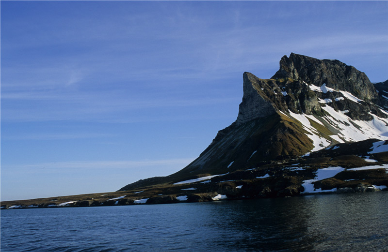
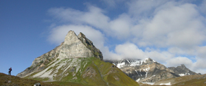
Alkhornet, at the northern entrance of Isfjorden, is a striking landmark. The landscape around this large bird cliff is lush and beautiful. East of Alkhornet you can find a deep and several kilometre long bay with an exciting and diverse history. Here you will find important and vulnerable cultural remains dating from several of Svalbard’s historical periods. Alkhornet and Trygghamna offer visitors an interesting combination of cultural history and natural environment. The name of Trygghamna, which literally means the safe harbour, refers to the good mooring conditions and the sheltered harbour offering lee of most winds.
 Alkhornet. (Image: Eva Fuglei/ The Norwegian Polar Institute) Take care:
- The Russian sites and graves in Trygghamna, and the cabin at Alkepynten which is falling to pieces, are protected cultural remains.
- Don’t walk on top of blubber ovens and house sites in Trygghamna.
- Goose location – be on the look-out for nesting birds and keep a good distance. Avoid scaring geese off the nests.
- There are Arctic fox dens in the area – keep a good distance to dens.
- There are some loose items around the cabin below Alkhornet – leave them untouched.
 Alkhornet and its green “skirt”. Conditions are good for the vegetation here, due to large amount of fertilizer brought to the cliff by birds in the form of guano, a calcareous bedrock and the southerly facing direction. (Image: Jørn Henriksen) Alkhornet and its green “skirt”. Conditions are good for the vegetation here, due to large amount of fertilizer brought to the cliff by birds in the form of guano, a calcareous bedrock and the southerly facing direction. (Image: Jørn Henriksen)
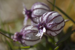 The polar campion (Silene uralensis) grows beneath Alkhornet, and is restricted to calcareous ground. (Image: Jørn Henriksen) The polar campion (Silene uralensis) grows beneath Alkhornet, and is restricted to calcareous ground. (Image: Jørn Henriksen)
 The graves are easily accessible in Trygghamna, leaving them vulnerable to damage. They are part of the most important cultural heritage from the early whaling around Svalbard. (Image: Guri Dahl / Svalbard Museum) The graves are easily accessible in Trygghamna, leaving them vulnerable to damage. They are part of the most important cultural heritage from the early whaling around Svalbard. (Image: Guri Dahl / Svalbard Museum)
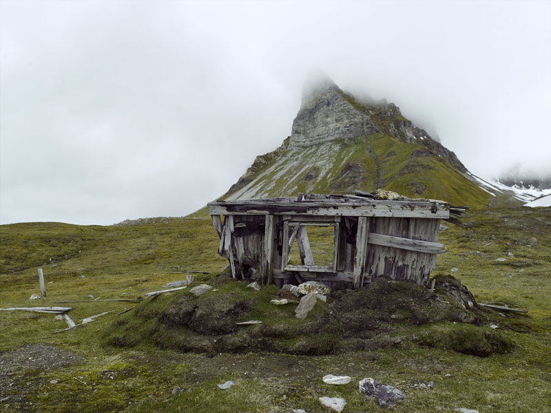
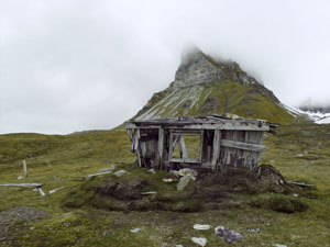 The cabin that Karl Eliassen built during World War I and sold to Hilmar Nøis in 1920. (Image: Guri Dahl / Svalbard Museum) The cabin that Karl Eliassen built during World War I and sold to Hilmar Nøis in 1920. (Image: Guri Dahl / Svalbard Museum)
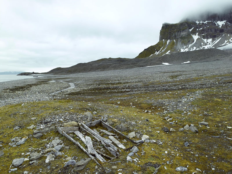
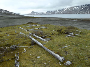 Russian Pomor sites, easily showing how remains of human activities leave green oases behind in barren landscapes. The sites are extremely vulnerable – do not walk in between the remains. Trygghamna and the anchoring sites can be seen in the background. (Image: Guri Dahl / Svalbard Museum) Russian Pomor sites, easily showing how remains of human activities leave green oases behind in barren landscapes. The sites are extremely vulnerable – do not walk in between the remains. Trygghamna and the anchoring sites can be seen in the background. (Image: Guri Dahl / Svalbard Museum)
The name Trygghamna is derived from the old Dutch name Behouden Haven and the English Safe Harbour or Safe Haven, all with the same meaning. The name reflects on the West European whaling that was carried out around Svalbard in the 17th century when whales would swim into the fjords and subsequently be caught. Trygghamna was, and still is, the perfect harbour with good anchorage. Because of its favourable geographical position, this harbour was early known and continuously in use.
Geologically speaking, the cliff Alkhornet chiefly consists of metamorphosed carbonate rocks, which is old bedrock, more than one billion years old. In contrast, on the other side of Trygghamna, Permian and Triassic rocks are dating back only about 200 to 300 million years. A short trip further east, to Erdmanflya at the Ymerbukta, sediments are very young – this strandflat is composed of marine deposits after the last ice age (< 10 000 years). Beneath Alkhornet there are fantastic rock formations of limestone that can be studied closely while walking in between the formations.
Harrietbreen and Kjerulfbreen are located innermost in Trygghamna, and these two glaciers previously had one common front terminating at the seafront. Today, none of them reach the bay. In front of the glaciers is an exciting landscape of moraines, quite easily accessible on foot. In contrast to Alkhornet, Trygghamna may seem lifeless, but you may see seals in the water and geese normally breed in the area around the pomor sites. Arriving at the foot of Alkhornet, this place boosts with life. Reindeer observations are common, there are several fox dens, geese nest on rocks and higher up, and the bird cliff is loaded with Brünnich’s guillemots in hundreds of thousands. The cliff also houses a large colony of kittiwakes. Often seen is the glaucous gull patrolling the air around the cliff for potential prey. Arctic skuas nest here as well. The moss tundra below the cliffs bear witness of constant influx of fertilizers and some areas are extraordinary lush for this reason.
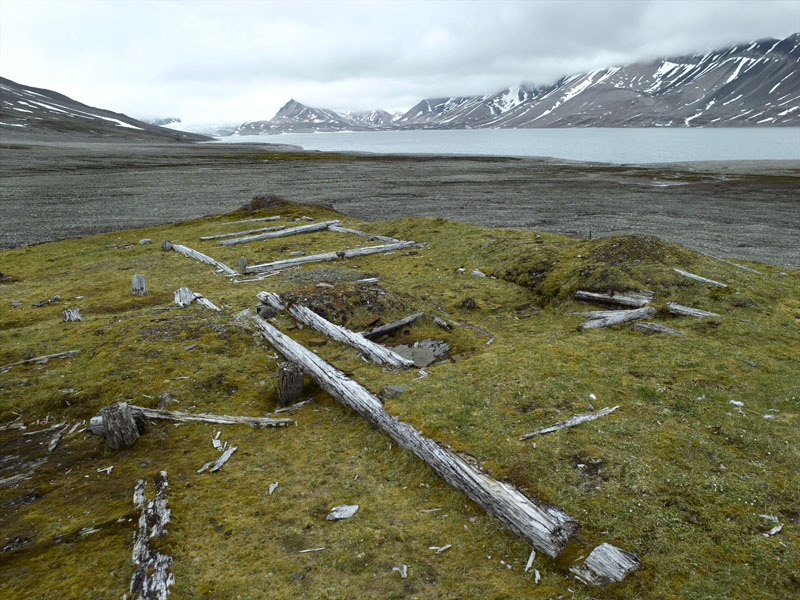
Remains of the old whaling activity can be found in Trygghamna in the form of green, well vegetated elevations just above the high tide mark. The elevations are remains of collapsed tryworks that were once used to render oil from whale blubber. Swells and ice have eroded the ovens over centuries and the contours are now being erased. Behind and inside the ovens are graves in strong deterioration over the course of time. All other traces of the earliest period in the history of Svalbard are gone from Trygghamna.
Many years after the whalers had left the area, hunting was re-introduced by Russian Pomors – they were hunters and trappers from the White Sea area in Russia. Traces of their activity in Trygghamna are visible as green spots on the barren ground. These traces are different from those of the whaling period. The Pomors left houses and cabins that through the assistance of nature and time became the sites and ruins you can see today. The remains of the buildings are easy to spot. They were built in so-called “drop wall” construction and/or cogging joints. Large red bricks were used to makes the fireplaces. In Trygghamna there are remains from two different Russian building constructions, both studied by archaeologists. One is a single cabin placed on the beach not far from the whaling tryworks. The other is the remains of one of the largest Russian trapping stations in Svalbard, consisting of five buildings closely connected. The larger two are over 40 m2 each, and were probably the living quarters. In the complex there are also remains of sauna, workshop and storages.
Below Alkhornet there are several interesting remains from the Norwegian overwintering hunting and trapping early 1900s. The most striking feature is the cabin thought to be erected by Karl Eliassen from Tromsø during World War I. The cabin was sold to hunter Hilmar Nøis in 1920 for overwintering in 1920-1921. Today, the cabin is in very bad repair and looks more like a casual heap of driftwood and logs. Even though it is falling to pieces, signs of the characteristic historical Svalbard construction are still visible, founded on the principle “Use what is at hand”. Cabins were built using the available materials; heavy planks, driftwood, crates. Cabins were disassembled and moved, and usable materials were used to build new trapping stations. Tar board once covered the cabin below Alkhornet. Newspapers and magazines were used for insulation and as cover for the inside walls. If looking closely, you may still be able to read parts of the histories presented in the magazines. Slowly the traces of this trapping station are being wiped out and both here and elsewhere it is important that visitors do not accelerate this process.
In the same area, out at the point, well protected from winds and hidden behind surrounding rock structures, lie the remains of an observation post dating from World War II. From the point of Alkepynten there is good view of the entrance to Isfjorden. This place served as observation post for the Norwegian troops in Barentsburg, on the opposite side of the fjord. Inside this site there are still remains of campfires. Long and cold hours were spent here watching for enemy ships and planes entering Isfjorden.
Vulnerable elementsThe Pomor sites in Trygghamna will not endure threading. Leave the course of nature unaffected by your presence. Geese nesting in the area should not be disturbed – foxes and gulls will steal their eggs if scared off the nests. Landing sitesMost vessels choose Trygghamna for anchoring. Trygghamna is deep and you will have to sail almost all the way in to find anchor depths. There is only a short distance to the Pomor sites and whaling remains. If conditions allow, it is also possible to land with small boats in a small bay just east of Alkepynten. This bay is located approximately 150 m west of the old cabin and can be identified by the eroded path from the beach up to the brink. Be aware that spring tide will flood the entire beach, and leave only a steep slope down to the water. Recommended trailsStarting at the Pomor sites you may hike southwards towards Alkepynten and Alkhornet. This route passes by one of the Governor of Svalbard’s cabins that houses field inspectors, on duty to collect biological data and inspect tourist traffic in the area. From the cabin there is a pronounced path towards Alkepynten – this is the best route. Before you reach Alkepynten you will pass the old ramshackle of a trapper’s cabin today situated right on the edge of the brink. From here you can make a turn and walk towards Alkhornet. After a little while you reach a plateau that offers great views both up to the cliff face and out the fjord, to the mouth of Isfjorden, Kapp Linné, the mountain of Festningen and Grønfjorden. If the visibility is good, you may see far into the Isfjorden.
|
The Cruise Handbook is also available in book form
Order now
Hard cover with numerous pictures - 249 pages - NOK 249.00
Norwegian Polar Institute
Fram Centre
NO-9296 Tromsø
NORWAY
|
 Norsk
Norsk