 Norsk
Norsk
Bjørnøya's geology and landscapeBy Øystein Overrein (ed.), Jørn Henriksen, Bjørn Fossli Johansen, Kristin Prestvold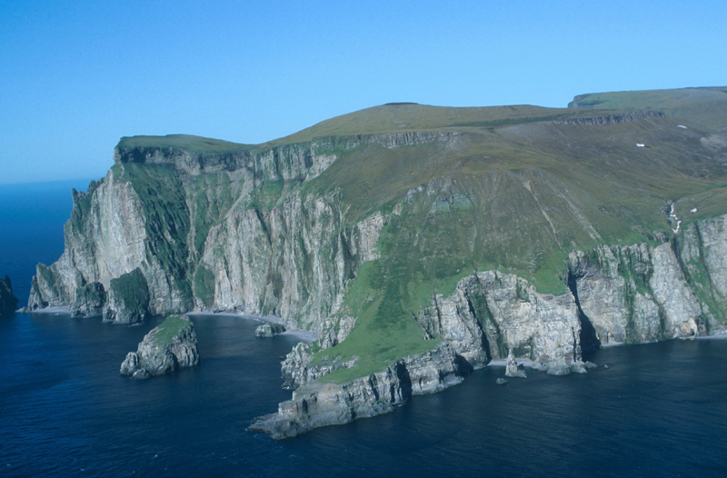


Bjørnøya seems very small in the vast Barents Sea that surrounds it. Only 20 km long from north to south and about 15 km at its widest, the island has an area of 178 km². The north and the west is predominately a plateau of up to 30-40 m.a.s.l., dotted with lakes and small ponds – approximately 740 in total, covering 10% of the area of the island. Most of the lakes are quite shallow. Ellasjøen is the deepest with its 35 m depth. The south and east are dominated by tall mountain formations, which tower at up to 500 m. The summit of Urd in Miseryfjellet is the tallest at 535 m.a.s.l. In the south there are steep cliffs, which are characteristic for this part of the island. These rise from the sea up to about 400 m. The dolomite pillars rising from the sea – Sylen (80 m) and Strappen (186 m) – are famous landmarks on the seaward side. On the northern coast there are several smaller sandy beaches. Apart from these, shoreline erosion has had a large impact on the coastline, creating a prominent edge along the shoreline, which makes landings difficult. There are many karst phenomena on the island such as caves and underground rivers, much like the karst formations found in Kongsfjorden. These caves and rivers can be found in the south in the valley Ymerdalen and in the river Jordbruelva. The oldest rocks on Bjørnøya are from the Precambrian and are between 600 and 1000 million years old. These can be found in the Antarcticfjellet in the south of the island. The youngest rocks are from the Triassic, and have an age of 210-245 million years. The bedrock consists of sedimentary rocks such as dolomite and limestone, sandstone, conglomerate and shale deposited in shallow sea areas, deltas, lakes and riverbanks. Many of the rocks contain fossils ammonites (spiral-shelled cephalopods), snails, brachiopods (benthic mussel-like animals) and corals. The bird cliffs in the south consist of dolomite limestone with horizontal ledges, ideal for breeding seabirds. The difference between high and low tide on Bjørnøya is 1.2–2.2 m. The climate is Arctic oceanic. Temperature differences between summer and winter are low. There is much wind and fog due to the prevailing polar lows, small-scale, short-lived atmospheric low pressure systems that develop over the ocean. Updated March 2015 |
The Cruise Handbook is also available in book formHard cover with numerous pictures - 249 pages - NOK 249.00 Norwegian Polar Institute |